Recently retrieved 19th-century map offers insight into Joseon Korea
by KoreaJoongAngDaily
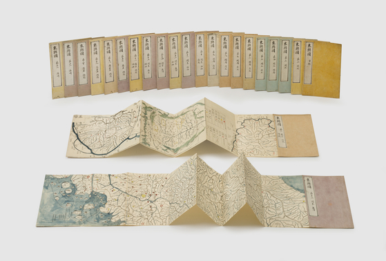
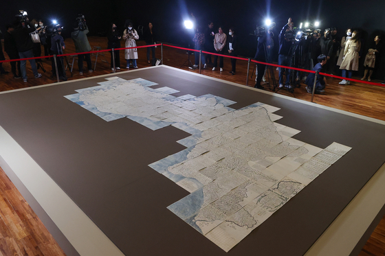
A rare version of Daedongyeojido, Korea's first large-scale map created in the 19th century by the Korean cartographer Kim Jeong-ho has made a return to Korea from Japan and was unveiled to local press on Thursday at the National Palace Museum of Korea in central Seoul. [YONHAP]
We now use our two fingers to zoom in and out of the maps available on our mobile devices that are updated constantly, providing us with detailed images and information of every nook and cranny of a location. But this certainly wasn’t the case in 19th century Korea.
To help Koreans navigate and recognize the location of where they were, a Joseon (1392-1910) geographer and cartographer named Kim Jeong-ho in 1861 decided to create the country’s very first large scale map of Korea, known as Daedongyeojido, which means “territorial map of the Great East” in English. The second edition was published in 1864 as an accordion-style foldable map.
Since then, different versions of maps with some variations were created using woodblocks. It’s unknown exactly how many copies of the first and second editions were made, but the Cultural Heritage Administration (CHA) believes there are about 35 surviving Daedongyeojido to date, 21 in Korea and 14 overseas. The figure was recently updated as one of the maps — the most exact variation according to experts — was returned back home from Japan.
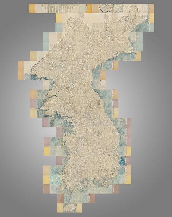
The CHA and the Overseas Korean Cultural Heritage Foundation unveiled the map to local media on Thursday at the National Palace Museum in central Seoul. The newly retrieved map that was carefully laid out in one of the exhibition halls of the museum, depicts roughly 47 kilometers (29 miles) of the Korean Peninsula, from north to south. When each foldable sheet — each measuring 20 by 30 centimeters — is laid out to form a whole map, it measures 4 meters wide and 6.7 meters long. The map consists of 23 sheets — 22 that feature different sections of the map and a catalog.
The returned Daedongyeojido consists of 23 sheets - 22 that feature different sections of the map and one catalog. [CHA]
According to the CHA, the recently retrieved version is rare as it’s a combination of a woodblock-printed edition produced in 1864 with the addition of annotations usually seen in Dongyeodo, otherwise known as the “Atlas of the Eastern State.”
Dongyeodo is another map created during the same period. Kim is believed to have consulted the map as source material for Daedongyeojido. It’s also referred to as a colored transcribed edition of Daedongyeojido. It features geographic information of Joseon, including traffic routes, military facilities and roughly 18,000 place names, whereas Daedongyeojido omits many place names and jugi (information recorded on the margins on the history of respective territories, cartographic techniques applied and instructions on how to use the maps).
In other words, the edition returned from Japan is Daedongyeojido, but includes the annotations usually seen in Dongyeodo in its margins, making it a “perfect combination.”
For example, on the second sheet which illustrates Mt. Baekdu and its neighboring regions, the Baekdusan National Boundary Monument and the distances between military facilities are shown, which are not noted in other woodblock-printed editions of Daedongyeojido. On the 14th sheet, which depicts Ulleung Island and its neighboring regions, it also has information of points of departure for ships heading to Ulleng Island, which is not found in other editions of Daedongyeojido.
The map measures 4 meters wide and 6.7 meters long when laid out. [CHA]
“That is why this retrieved map provides the most exact information about the Korean Peninsula among the surviving Daedongyeojido,” said Kim Ki-hyuk, professor emeritus of Geographic Education at Pusan National University, who was at the press conference on Thursday to explain the significance of the retrieved edition of Daedongyeojido. Kim says it would’ve been difficult to include jugi in the usual Daedongyeojido because of the difficulties of carving so much detail on woodblocks.
“This retrieved edition will provide material for the study of the production and use of maps during the Joseon Dynasty,” said Kim. “It will also expand the scope of research on Joseon-era geographic information as the first woodblock-printed edition with transcribed annotations from Dongyeodo that has been identified to date.”
The CHA has not specified the date when the retrieved map will be available for the public to view, but said it will soon organize an exhibit to showcase the map.
Reference Written by YIM SEUNG-HYE [yim.seunghye@joongang.co.kr] Provided by Korea JoongAng Daily
※ Picks respects the rights of all copyright holders. If you do wish to make material edits, you will need to run them by the copyright holder for approval.
more from
KoreaJoongAngDaily
KoreaJoongAngDaily
Busan's Festival Shiwol back and better than ever this September
2025-06-26 00:00:00
KoreaJoongAngDaily
Japan returns Joseon-era royal shrine in effort with Korea
2025-06-25 00:00:00
KoreaJoongAngDaily
Seoul to begin trial rides for Han River ferry in July
2025-06-24 00:00:00
KoreaJoongAngDaily
Rare chance to explore Mount Halla's crater lake expanded due to overwhelming demand
2025-06-23 00:00:00
BEST STORIES
KoreaJoongAngDaily
In the age of TripAdvisor, travel agencies get creative to court Gen Z
2025-06-22 00:00:00
Visit Dubai
Dreaming of a Dubai beach holiday?
2025-06-21 00:00:00
AllblancTV
Super Morning Fullbody Home Workout (Part 1/2)
2025-06-23 00:00:00
Inven Global
Netmarble Launches Game of Thrones: Kingsroad on iOS, Android and PC
2025-06-21 00:00:00
Lifestyle
KoreaJoongAngDaily
Joggers join hands with police to help keep city safe with new 'Seoul Running Patrol'
2025-06-22 00:00:00
KoreaJoongAngDaily
Seoul to honor veterans with memorial spaces, boosted benefits
2025-06-19 00:00:00
KoreaJoongAngDaily
Seoul to reopen Han River pools for summer with affordable entry, safety checks
2025-06-19 00:00:00
KoreaJoongAngDaily
Jeju reaps rewards from ‘Tangerines’ tourism after Netflix hit
 A rare version of Daedongyeojido, Korea's first large-scale map created in the 19th century by the Korean cartographer Kim Jeong-ho has made a return to Korea from Japan and was unveiled to local press on Thursday at the National Palace Museum of Korea in central Seoul. [YONHAP]