Alaska's near‑record landslide tsunami sent a wave 1,580 feet up the fjord walls - and left clues for building a warning system
by The Conversation
The Tracy Arm landslide sent a tsunami wave far up the opposite side of the fjord near South Sawyer Glacier. John Lyons/U.S. Geological Survey
On the evening of Aug. 9, 2025, passengers on the Hanse Explorer finished taking selfies and videos of the South Sawyer Glacier, and the ship headed back down the fjord. Twelve hours later, a landslide from the adjacent mountain unexpectedly collapsed into the fjord, initiating the second-highest tsunami in recorded history.
The Tracy Arm landslide generated a tsunami that sent a wave so high up the opposite fjord wall that it would have overtopped some of the world’s tallest buildings. Here’s how it compares to other large tsunamis around the world. Steve Hicks/University College London
It was just after 5 o’clock in the morning on a dreary day, and fortunately, no ships were nearby. In the months after, some cruise lines started avoiding Tracy Arm. However, the conditions that led to this event are not at all unique to this fjord.
Landslides are common in the coastal mountains of Alaska where rapid uplift, caused by tectonic forces and long-term ice loss, converges with the erosive forces of precipitation and moving glaciers. But a curious pattern has emerged in recent years: Multiple major landslides have occurred precisely at the terminus of a retreating glacier.
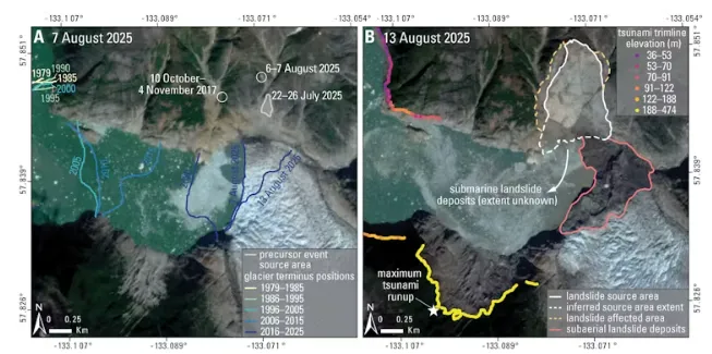
Though the mechanics are still poorly understood, these mountains appear to become unstable when the ice disappears. When the landslide hits the water, the momentum of millions of tons of rock is transferred into tsunami waves.Maps show how the glacier has retreated over the years, moving past the section of mountain that collapsed (outlined in white on the right) in the days prior to the slide. The map on the right shows the height the tsunami reached on the fjord walls. Planet Labs
This same phenomenon is playing out from Alaska to Greenland and Norway, sometimes with deadly consequences. Across the Arctic, countries are trying to come to terms with this growing hazard. The options are not attractive: avoid vast swaths of coastline, or live with a poorly understood risk. We believe there is an obvious role for alert systems, but only if scientists have a better understanding of where and when landslides are likely to occur.
Signs that a landslide might be coming
The Tracy Arm landslide is a powerful example.
The landslide occurred in August, when warm ocean waters and heavier precipitation favor both glacier retreat and slope failure. The glacier below the landslide area had experienced rapid calving – large chunks of ice breaking off and falling into the water – and it had retreated more than a third of a mile in the two months prior. Heavy rain had been falling. Rain enters fractures in the mountain and pushes them closer to failure by increasing the water pressure in cracks.
Most provocative are the thousands of small seismic tremors that emanated from the area of the slide in the days prior to the mountainside collapsing.
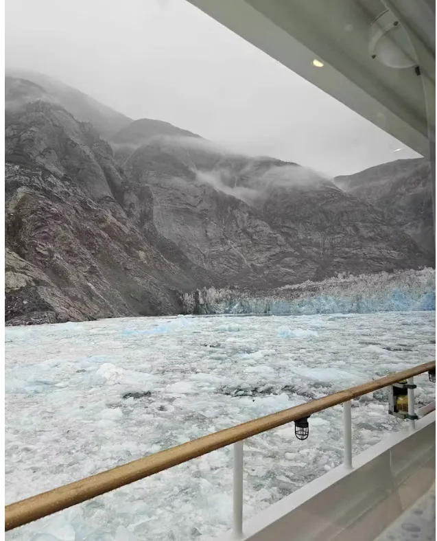
The view from the deck of the Hanse Explorer on Aug. 9, 2025, shows the mountain where the landslide occurred just 12 hours before it happened. Hanse Explorer
We believe that this combination of signs would have been sufficient to issue progressive alerts to any ships in the vicinity and homes and businesses that could have been harmed by a tsunami at least a day prior to the failure – had a monitoring program existed.
For example, though people are still killed in avalanches, alert systems have played an essential role in making winter backcountry travel safer for more people. The collapse at Tracy Arm demonstrates what could be possible for landslides.
What an alert system could look like
We believe that the combination of weather and rapid glacier retreat in early August 2025 was likely sufficient to issue an alert notifying people that the hazard may be temporarily elevated in a general area. On a yellow-orange-red scale, this would be a yellow alert.
In the hours prior to the landslide, the exponential increase in seismic events and telltale transition to what is known as seismic tremor – a continuous “hum” of seismic energy – were sufficient to communicate a time-sensitive warning for a specific region.
These observations, recorded as a byproduct of regional earthquake monitoring, warranted an “orange” alert noting immediate concern. The signs were arguably sufficient to recommend keeping boats and ships out of the fjord.
Our research over the past few years has demonstrated that once a large landslide has started, it is possible to detect and measure the event within a couple of minutes. In this amount of time, seismic waves in the surrounding area can indicate the rough size of the landslide and whether it occurred near open water.
A monitoring program that could quickly communicate this would be able to issue a red alert, signaling an event in progress.
The National Oceanic and Atmospheric Administration’s tsunami warning program has spent decades fine-tuning rapid message dissemination. A warning system would have offered little help for ships in the immediate vicinity, but it could have provided perhaps 10 minutes of warning for those who rode out the harrowing tsunami farther away.
There is no landslide monitoring system operating yet at this scale in the U.S. Building one will require cooperation across state and federal agencies, and strengthened monitoring and communication networks. Even then, it will not be fail-proof.
Understanding risk, not removing it
Alert systems do not remove the risk entirely, but they are a better option than no warning at all. Over time, they also build awareness as communities and visitors get used to thinking about these hazards.
Many of the most alluring places on Earth come with significant hazards. Arctic fjords are among them. The same processes that create this hazard – glacier retreat, steep terrain, dynamic geology – are also what make these landscapes so compelling. The mix of glaciers, ice-choked waters and steep mountains is exactly what draws people to these places. People will continue to visit and experience them.
The question is not whether these places should be avoided altogether, but how to help people make more informed decisions. We believe that stronger geophysical and meteorological monitoring, coupled with new research and communication channels, is the first step.
On Aug. 9, visitors unknowingly passed through a landscape on the cusp of failure. An alert system might have given tour companies and people in the area the information they needed to make more informed choices and avoid being caught by surprise.
※ Picks respects the rights of all copyright holders. If you do wish to make material edits, you will need to run them by the copyright holder for approval.
more from
The Conversation
The Conversation
How tarot readers are using AI – and what it says about our growing reliance on chatbots for emotional support and advice
2026-05-16 00:00:00
The Conversation
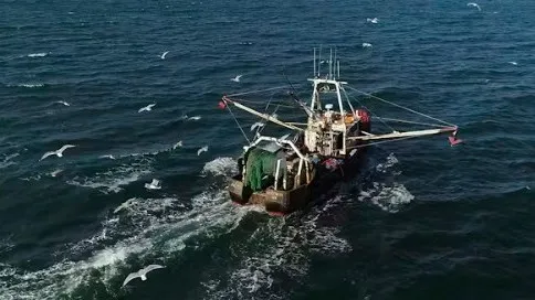
Bottom trawling is scraping oceans of wildlife
2026-05-16 00:00:00
The Conversation
We tested the new World Cup ball – this is what you need to know about how it will fly, dip and swerve
2026-05-15 00:00:00
The Conversation
Protecting pollinating insects could improve diets and livelihoods worldwide – new study
2026-05-15 00:00:00
BEST STORIES
Mindswitch
Crispy Golden French Fries
2026-05-11 00:00:00
Travie
Play Baseball, Meet Cats: Jeju's Wildest New Theme Parks Are Open
2026-05-10 00:00:00
Knowable Magazine
Do you take after your dad's RNA?
2026-05-12 00:00:00
Inven Global
Pearl Abyss Adds Difficulty Settings to 'Crimson Desert'
2026-05-11 00:00:00
Environment
The Conversation
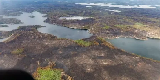
New research highlights how wildfires are harming fish
2026-05-15 00:00:00
The Conversation
Other countries can learn from the UK’s successful shift to fortnightly bin collections
2026-05-15 00:00:00
The Conversation
Suspending federal gas tax wouldn’t save drivers as much as they might hope – here’s what goes into the price of a gallon of gas
2026-05-14 00:00:00
The Conversation
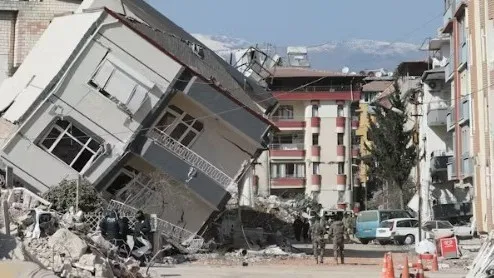
'Seismic whiplash'- new research shows what happens when earthquakes stop suddenly
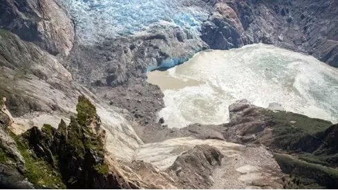 The Tracy Arm landslide sent a tsunami wave far up the opposite side of the fjord near South Sawyer Glacier. John Lyons/U.S. Geological Survey
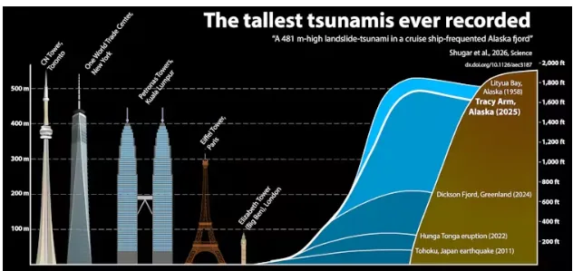
 Reference