But, how do they know what’s likely to happen months in the future?
I’m an atmospheric scientist who studies extreme weather. Let’s take a look at what Atlantic hurricane forecasts are based on and why those forecasts can shift during the season, which runs from June 1 to Nov. 30.
What goes into a seasonal forecast
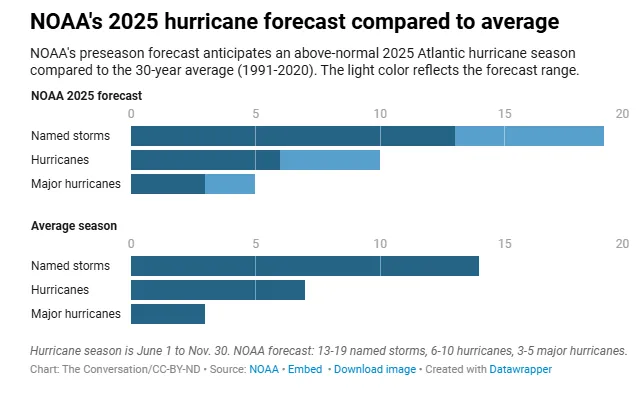
Think of the preseason hurricane forecast as the 30,000-foot view: It can’t predict if or when a storm will hit a particular location, but it can offer insight into how many storms are likely to form throughout the entire Atlantic, and how active the season overall might be.
These outlooks rely heavily on two large-scale climate factors.
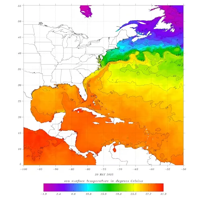
The first is the sea surface temperature in areas where tropical cyclones tend to form and grow. Hurricanes draw their energy from warm ocean water. So when the Atlantic is unusually warm, as it has been in recent years, it provides more fuel for storms to form and intensify.
Once water temperatures are 79 degrees Fahrenheit (26 degrees Celsius), hurricanes can form. Most of the Gulf was above that by late May 2025. NOAA/NESDIS
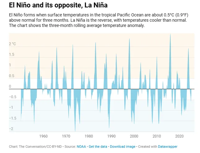
The second key ingredient that meteorologists have their eye on is the El Niño–Southern Oscillation, which forecasters refer to as ENSO. ENSO is a climate cycle that shifts every few years between three main phases: El Niño, La Niña, and a neutral space that lives somewhere in between.
During El Niño, winds over the Atlantic high up in the troposphere – roughly 25,000 to 40,000 feet – strengthen and can disrupt storms and hurricanes. La Niña, on the other hand, tends to reduce these winds, making it easier for storms to form and grow. When you look over the historical hurricane record, La Niña years have tended to be busier than their El Niño counterparts, as we saw from 2020 through 2023.
We’re in the neutral phase as the 2025 hurricane season begins, and probably will be for at least a few more months. That means upper-level winds aren’t particularly hostile to hurricanes, but they’re not exactly rolling out the red carpet either.
It’s important to emphasize that these factors merely load the dice, tilting the odds toward more or fewer storms, but not guaranteeing an outcome. A host of other variables influence whether a storm actually forms, how strong it becomes, and whether it ever threatens land.
The smaller influences forecasters can’t see yet
Once hurricane season is underway, forecasters start paying close attention to shorter-term influences.
These subseasonal factors evolve quickly enough that they don’t shape the entire season. However, they can noticeably raise or lower the chances for storms developing in the coming two to four weeks.
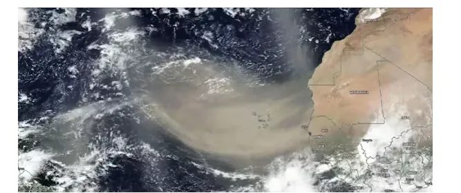
These dust plumes tend to suppress hurricanes by drying out the atmosphere and reducing sunlight that reaches the ocean surface. Dust outbreaks are next-to-impossible to predict months in advance, but satellite observations of growing plumes can give forecasters a heads-up a couple weeks before the dust reaches the primary hurricane development region off the coast of Africa.
Dust blowing in from the Sahara Desert can tamp down hurricane activities by shading the ocean over the main development region for hurricanes and drying out the atmosphere, just off the African coast. This plume spread over 2,000 miles in June 2020. NASA
Another key ingredient that doesn’t go into seasonal forecasts but becomes important during the season are African easterly waves. These “waves” are clusters of thunderstorms that roll off the West African coast, tracking from east to west across the ocean. Most major storms in the Atlantic basin, especially in the peak months of August and September, can trace their origins back to one of these waves.
Forecasters monitor strong waves as they begin their westward journey across the Atlantic, knowing they can provide some abouinsightt potential risks to U.S. interests one to two weeks in advance.
Also in this subseasonal mix is the Madden–Julian Oscillation. The MJO is a wave-like pulse of atmospheric activity that moves slowly around the tropics every 30 to 60 days. When the MJO is active over the Atlantic, it enhances the formation of thunderstorms associated with hurricanes. In its suppressed phase, storm activity tends to die down. The MJO doesn’t guarantee storms – or a lack of them – but it turns up or down the odds. Its phase and position can be tracked two or three weeks in advance.
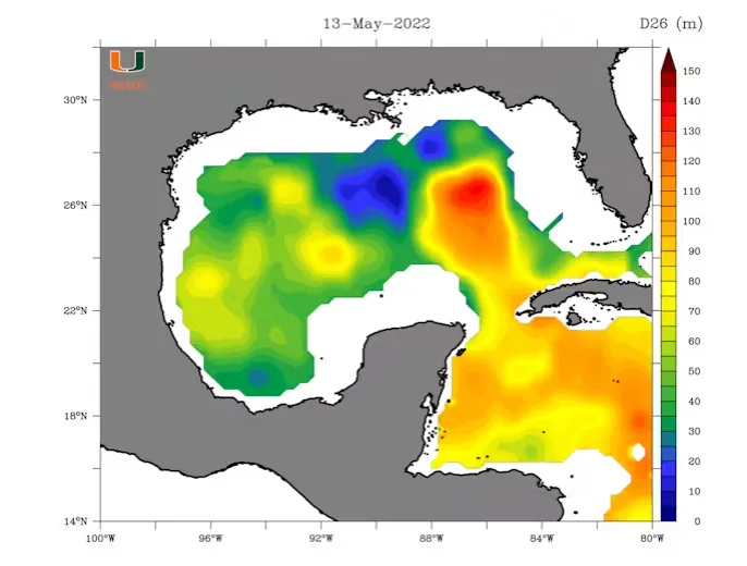
Lastly, forecasters will talk about the Loop Current, a deep river of warm water that flows from the Caribbean into the Gulf of Mexico.
When storms pass over the Loop Current or its warm eddies, they can rapidly intensify because they are drawing energy from not just the warm surface water but from warm water that’s tens of meters deep. The Loop Current has helped power several historic Gulf storms, including Hurricanes Katrina in 2005 and Ida in 2021.
The Loop Current stretched well into the Gulf in May 2022. The scale, in meters, shows the maximum depth at which temperatures were 78 F (26 C) or greater. Nick Shay/University of Miami, CC BY-ND
But the Loop Current is always shifting. Its strength and location in early summer may look very different by late August or September.
Combined, these subseasonal signals help forecasters fine-tune their outlooks as the season unfolds.
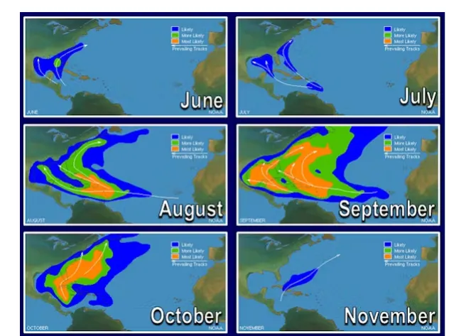
In early summer, the Gulf of Mexico warms up faster than the open Atlantic, making it a notable hotspot for early-season tropical storm development, especially in June and July. The Texas coast, Louisiana, and the Florida Panhandle often face a higher early-season risk than locations along the Eastern seaboard.
These are generally the busiest areas during each month of hurricane season, but that doesn’t mean hurricanes won’t make landfall elsewhere. NOAA
By August and September, the season reaches its peak. This is when those waves moving off the coast of Africa become a primary source of storm activity. These long-track storms are sometimes called “Cape Verde hurricanes” because they originate near the Cape Verde Islands off the African coast. While many stay over open water, others can gather steam and track toward the Caribbean, Florida or the Carolinas.
Later in the hurricane season, storms are more likely to form in the western Atlantic or Caribbean, where waters are still warm and upper-level winds remain favorable. These late-season systems have a higher probability of following atypical paths, as Sandy did in 2012 when it struck the New York City region and Milton did in 2024 before making landfall in Florida.
At the end of the day, the safest way to think about hurricane season is this: If you live along the coast, don’t let your guard down. Areas susceptible to hurricanes are never totally immune from hurricanes, and it only takes one to make it a dangerous – and unforgettable – season.
※ Picks respects the rights of all copyright holders. If you do wish to make material edits, you will need to run them by the copyright holder for approva
more from
The Conversation
The Conversation
Meet ‘lite intermediate black holes,’ the supermassive black hole’s smaller, much more mysterious cousin
2025-08-07 00:00:00
The Conversation
Why do some clothes shrink in the wash? A textile scientist explains how to ‘unshrink’ them
2025-08-07 00:00:00
The Conversation
How can I tell if I am lonely? What are some of the signs?
2025-08-06 00:00:00
The Conversation
Why do I feel so emotional when I listen to music from my teenage years?
2025-08-06 00:00:00
BEST STORIES
AFP
'Japan sees new record high temperature of 41.2C'
2025-08-02 00:00:00
The Conversation
Older adults who follow healthy diets accumulate chronic diseases more slowly – new study
2025-08-01 00:00:00
AllblancTV
Try This Beginner Super Sweat Fullbody Workout(Part 2/2)
2025-08-04 00:00:00
Inven Global
VALORANT Champion TenZ Joins Red Bull’s Competitive Roster
2025-08-01 00:00:00
Environment
The Conversation
'Darkening' cities is as important for wildlife as greening them
2025-08-05 00:00:00
The Conversation
Flames to floods: how Europe's devastating wildfires are fuelling its next climate crisis
2025-08-05 00:00:00
The Conversation
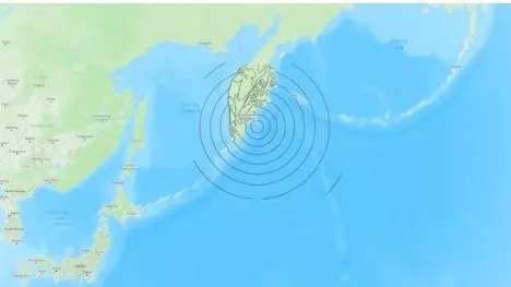
'Kamchatka earthquake is among top 10 strongest ever recorded. Here's what they have in common'
2025-08-04 00:00:00
The Conversation
Three types of drought - and why there's no such thing as a global water crisis
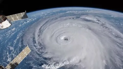 The view of Hurricane Florence from the International Space Station in 2018. NASA/Goddard Space Flight Center